Je dois en fait ma première intuition des cartes de distances à la communication de Gert J. van Tonder au colloque Ffractarq’04 (The 1st International Conference on Foundations for Fractal Architecture in the 21st Century, Madrid). Son papier, intitulé « Fractal potential of ‘emptiness’ in Japanese dry rock gardens » (disponible ici), parlait d’« axes médians », et son but était de montrer le caractère fractal (ou plutôt arborescent) de la structure du vide dans les jardins zen (composés de gravier et de pierres). J’eus donc l’idée de réaliser ce que j’ai appelé plus tard une carte des distances par rapport à des « centres » correspondant aux pierres d’un jardin zen imaginaire : I actually owe my first intuition of distance maps to Gert J. van Tonder’s paper at Ffractarq’04 (The 1st International Conference on Foundations for Fractal Architecture in the 21st Century, Madrid). His paper, titled «Fractal potential of ‘emptiness’ in Japanese dry rock gardens» (available here), was about «medial axes», and his aim was to show the fractal quality (or rather the tree-like one) of the strucure of the empty space in Japanese rock gardens. I therefore had the idea to compute what I later called a distance map with the «centres» being the rocks of an imaginary rock garden:
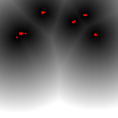
Je reviendrai sur cet exemple et ses implications. Dans la foulée, j’ai expérimenté les cartes de distances sur un certain nombre de configurations de centres :
I shall return later on this example and its implications. I experimented at the time other distance maps on some of configurations of centres:
2 points :
3 points :
12 points sur un cercle / 12 points on a circle :
plus de points sur un cercle / more points on a circle :
des points en spirale / points on a spiral :
plus de points sur une spirale / more points on a spiral :
une cardioïde /a cardioid:
où l'on voit apparaître fantomatiquement le cercle fixe autour duquel tourne le cercle qui permet de définir cette courbe comme trajectoire (explications
ici).
where we can see the ghost of the circle around which rolls the circle that permits to define this curve (explanations here)
une autre cardioïde avec moins de points /another cardioid with less points:
A noter que dans ces images, j'ai grossi la taille des centres (points rouges) pour une meilleure visibilité. En réalité, ils font seulement un pixel.
Let's remark that in those pictures I enlarged the centres (red dots) in order to better see them. Their size is actually one pixel.


